


"The successful integration of FloodMapp's technology into Waze has the potential to save property and lives and help coastal communities worldwide adapt to the threats from climate change."

Paul Robinson
RISE Executive Director

Flooding has been a part of most people's lives in Norfolk, Virginia for the last century, however in more recent years, flooding has become more problematic and a risk to public safety.
A major problem experienced throughout the city is the increased frequency of flooded roads causing significant disruptions to transport which impacts economic and social activity.
Background
The City of Norfolk had access to a lot of information including flood sensors, and static flood studies. But given the speed and scale of unfolding flood events, little actionable intelligence was available. Any solution to this problem had to be timely, accurate, and targeted. The City sought help from RISE; who put out a global call with their Urban Mobility Resilience Challenge, seeking real-time flood modeling technology which can be used to help traffic navigate around flooded roads.
FloodMapp, through RISE Resilience Innovations' Urban Mobility Resilience Challenge, was selected and worked with the City of Norfolk to understand their detailed use case requirements to solve this challenge.
The Problem
The Solution

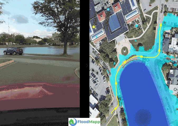
Leveraging the power of NowCast's real-time capability, FloodMapp was able to identify and access the data needed to meet the speed, accuracy, and granularity required. NowCast was implemented to run and refresh results every 15 minutes as new tidal and rainfall observations are ingested, producing 1 meter resolution flood inundation models, accurate within inches.
City road data was used in RoadSafe, a powerful analytics service which predicts flooded roads based on NowCast inundation data. Flood depth thresholds, developed in collaboration with the City, are used to define road hazards and road closures respectively based on the depth of flooding over each road segment.
The solution was then delivered to Norfolk’s ArcGIS Online organization, where they can view live road closures and road hazard segments which update dynamically as a flood unfolds.
The Outcome
FloodMapp NowCast and RoadSafe flood intelligence are delivered and rendered as a City-wide common operating picture and single point of truth via Esri’s ArcGIS Online and ArcGIS Pro systems. This provides the City of Norfolk staff and Emergency Operations Centre (EOC) with hyper-local flood intelligence in real-time. This vital situational awareness has helped to inform emergency managers and public works officials in their operational response to flooding, which supports in delivering community messaging, planning, and response decision-making.
Concurrently, citizens can access FloodMapp RoadSafe via their Waze App, which quickly alerts them to flood hazards in real-time and enables safe route planning to navigate away from delay or danger.
Since launching the system live to residents in October 2021, Waze users confirmed more than 18,103 flooded roads predicted by FloodMapp RoadSafe. Drivers have provided over 42,683 thumbs-ups to validate these predictions (an average of 2.36 and a maximum of 74 confirmations per hazard).

.jpg)


