
Understanding the Community Rating System (CRS): How FloodMapp Helps Communities Earn Points
- Feb 25, 2025
- 5 min read
Updated: Mar 21, 2025
What is the Community Rating System (CRS)?
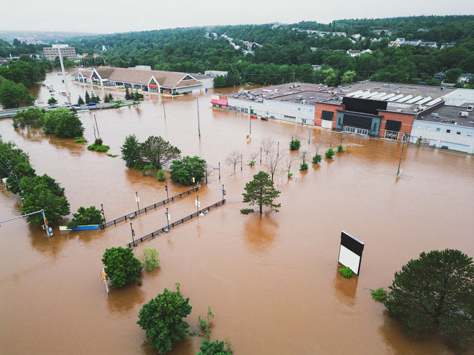
Flooding is the most common and costly natural disaster in the United States, and for communities enrolled in FEMA’s Community Rating System (CRS), there’s an opportunity to reduce the financial burden on residents through proactive flood mitigation efforts.
CRS is a voluntary program under the National Flood Insurance Program (NFIP) that recognizes and incentivizes communities who reduce their flood risk through proactive measures like improved floodplain management, early warning systems, and public awareness initiatives.
Communities that meet CRS criteria can improve their CRS Class Rating and subsequently reduce NFIP flood insurance premiums for residents in Special Flood Hazard Areas (SHFA). The better the rating (on a scale from Class 10 to Class 1), the larger the discount—up to 45% off NFIP flood insurance policies for communities achieving the highest CRS classifications.
How Do Communities Earn CRS Points?
Communities earn points to improve CRS Class Rating by implementing flood risk reduction activities in categories such as:
Public Information – Keeping residents informed about flood hazards and safety measures.
Mapping & Regulations – Ensuring accurate flood maps and strict floodplain management regulations.
Flood Damage Reduction – Implementing mitigation projects and infrastructure improvements.
Warning & Response Systems – Improving flood warning systems and emergency response planning.
But earning and maintaining CRS points can be a complex and resource-intensive process, requiring communities to continuously assess, report, and implement new strategies for flood risk reduction.

How FloodMapp Helps Communities Improve CRS Ratings
FloodMapp supports CRS credit-earning activities by providing communities with highly accurate, real-time flood data before, during, and after flood events. By integrating FloodMapp’s ForeCast, NowCast, and PostCast solutions, communities can enhance public safety, flood response, and long-term resilience planning while earning CRS points in key activities, including:
Flood Warning & Response (Activity 610):
Deliver faster, more accurate public flood warnings, reducing damage and improving emergency response efforts.
Coordinate flood response activities such as road closures and traffic routing.
Keep residents informed of road closures, flood risk, and emergency updates in a clear and accessible way with FloodMapp-powered alerts.
Public Information: Map Information Service (Activity 320) & Flood Protection Information (Activity 350):
FloodMapp PostCast and our Flood Atlas historical library can support communities with information on recent and historical flood events to help them understand and contextualize their flood risk.
These tools allow local governments to display real-world flood data alongside Flood Insurance Rate Maps (FIRMs) to support community education and awareness.
By making flood information more accessible, communities can educate residents and strengthen floodplain management efforts, supporting CRS public information activities.
Improved Mapping & Regulations (Activity 440):
FloodMapp PostCast provides high-resolution flood extent data that helps communities:
Update flood maps with real-world flood impact data.
Plan mitigation projects based on historical flood patterns.
Make data-driven policy decisions to enhance floodplain management.
Accurate mapping is essential for communities looking to earn CRS points in this category while also improving long-term flood resilience.
Floodplain Management Planning (Activity 510)
FloodMapp PostCast supports communities in conducting Repetitive Loss Area Analyses by:
Identifying areas most susceptible to flood risk.
Pinpointing public assets most vulnerable to flooding.
Providing data to support CRS-driven flood hazard mitigation planning.
Acquisition and Relocation (Activity 520)
FloodMapp PostCast can be used to identify properties that have suffered repeated flood loss, supporting initiatives to:
Acquire or relocate insurable buildings out of floodplains.
Convert high-risk properties into open space to reduce future flood risk.
Flood Protection (Activity 530)
FloodMapp PostCast can be used to identify high-risk properties which have suffered recent and repeated flooding, which could benefit from:
Floodproofing
Elevation
Minor structural projects
FloodMapp ForeCast could be used to identify areas at risk of impact before flooding occurs, allowing communities to:
Deploy temporary flood barriers and protection measures.
Reduce damage and mitigate flood impact in real time.
FloodMapp’s real-time flood intelligence directly aligns with several CRS activities, with Activity 610: Flood Warning and Response being the strongest connection. This activity focuses on the principle that ample warning, combined with a flood response plan, can reduce loss of life and property damage, ultimately helping communities lower the CRS rating and save residents money on flood insurance premiums.
Communities can earn CRS credits in this category with the support of FloodMapp through:
Advance notification of an impending flood (up to 75 points)
Issuing warnings to the threatened population (up to 75 points)
Taking steps to protect life and reduce losses during the flood (up to 115 points)
Coordinating with critical facilities (up to 75 points)
Being StormReady certified (up to 25 points)

Aligning CRS Goals with Emergency Management & Public Works Budgets
One of the biggest challenges for communities aiming to improve their CRS rating is securing funding for new flood resilience initiatives. Physical flood mitigation projects such as levees involve major infrastructure spend and construction timeframes. Similarly, property acquisition and relocation can be expensive and involve lengthy planning cycles.
In contrast, flood intelligence software solutions like FloodMapp are cost effective and can be deployed rapidly. They can also benefit multiple departments, making them easier to justify within existing city and county budgets or through grant funding opportunities.
In this way, an investment into flood intelligence software may outperform in terms of return on investment for hazard mitigation and damage reduction as well as CRS rating improvements, and NFIP insurance reduction.
Many communities successfully secure funding for flood intelligence solutions by aligning their flood mitigation goals with broader city-wide resilience strategies, working across departments to build effective business cases, leverage shared budgets and maximize available funding.
Grant Program | Eligible Applicants | How FloodMapp Supports Funding Goals |
|---|---|---|
State, territorial, local, and tribal governments with NFIP-insured properties | Supports flood hazard mitigation planning by providing real-time and historical flood data for risk reduction. Helps identify high-risk areas and support acquisition/relocation projects. | |
State, local, and tribal governments with a major disaster declaration in the past seven years | Supports hazard mitigation planning by providing real-time and historical flood data for risk assessments. Helps communities scope and prioritize mitigation projects using predictive flood modeling. Enhances planning-related activities by improving flood risk communication and preparedness strategies. | |
State, local, tribal, and territorial governments after a declared disaster | Helps communities assess flood risk and implement long-term mitigation strategies. Provides data for repetitive loss area analyses to understand the most vulnerable areas and compare Hazard mitigation projects to get the best return on investment (i.e. floodplain buyouts and relocations, elevated homes, levees etc.) | |
State and local governments, federally recognized tribes, planning organizations, U.S. territories | Uses real-time flood data for transportation resilience and traffic safety improvements. FloodMapp’s operational intelligence on impacted roads assists in flood-aware road planning and emergency rerouting during high-water events. |
Norfolk, VA: A CRS Success Story
The City of Norfolk, VA, has taken proactive steps toward improving its CRS Class Rating by integrating real-time flood intelligence into its Program for Public Information. By leveraging FloodMapp’s NowCast technology and integrating flood data with Waze, Norfolk has enhanced public communication, redirected drivers from flooded roads, and strengthened its flood warning and response efforts.
As a result, Norfolk has improved its CRS Class Rating, providing significant flood insurance savings for residents while continuing to build a more resilient community.


What an inspiring piece! 소액결제현금화 You've done an excellent job breaking down this complex topic in such an accessible way. Thanks for keeping us informed and motivated!
What a fantastic piece! 소액결제 현금화 This really highlights the important work being done in the community, and I appreciate the thorough reporting and fresh perspective. Keep up the excellent journalism!
Wow, this is super helpful! I had no idea there was a whole point system behind flood insurance discounts. Makes me wonder if my town is even enrolled in CRS—guess I’ve got some research to do. Riddle School
This is exactly the kind of thoughtful, well-researched journalism we need more of! 소액결제 현금화 The way you broke down this complex topic made it so easy to understand, and I really appreciated the balanced perspective throughout. Keep up the fantastic work!
Excellent piece! This is exactly the kind of thoughtful, well-researched reporting we need more of. 정보이용료 현금화 Really appreciate you taking the time to cover this important topic so thoroughly!