
Another 'Wet' Wet Season for QLD and NSW
- Sep 6, 2022
- 3 min read
2022/2023 Wet Season – Preparation is key!
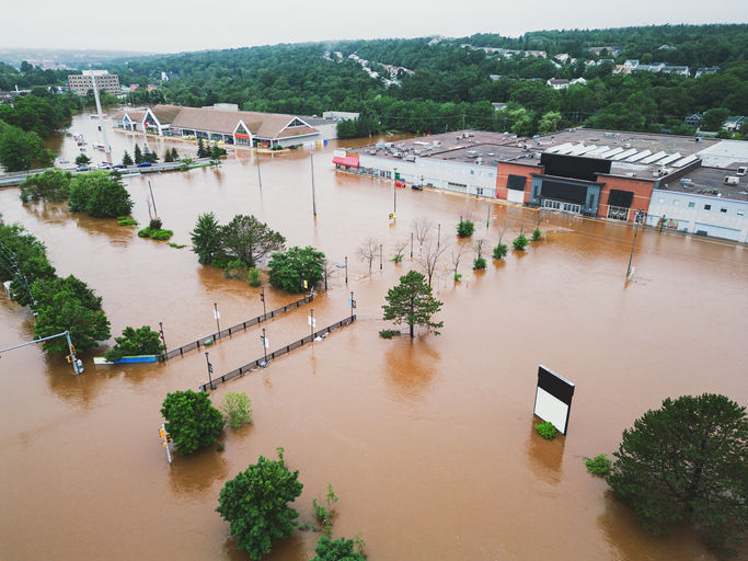
The past 12 months has seen significantly above average rainfall for most of Queensland and New South Wales, especially along the east coast. The continued winter rainfall means soil moisture levels are above average and catchments are highly responsive to rainfall events.

There are a few climate drivers which can influence whether there is an increased risk of above average rainfall, particularly for the east coast of Australia. These typically are the Indian Ocean Dipole (IOD) and El Nino Southern Oscillation Index (ENSO). BoM have an informative video summarising these climate drivers here.
BOM issued the Spring 2022 Climate and Water Outlook (here) which indicated further above average spring rain for the east coast of Australia. BoM have maintained the ENSO outlook as La Nina Alert with a 70% chance of a La Nina event being declared. BoM are also advising of a negative IOD as well as a Positive Southern Annual Mode (SAM).

Whether La Nina is or isn’t declared for the upcoming wet season doesn’t change our required focus on preparation for potential flood events. With soil moisture levels across the eastern half of Australia are significantly above average, even average thunderstorm, cyclone and tropical low activity has the potential to cause flooding to local creeks and river systems due to an increase in runoff.
Are you prepared? It is important to start planning how best to be prepared. The Get Ready programs are run by all State Government and Territories are based around knowing your risk and preparing a plan. Get Ready Queensland has a video summarising flood risk here.
Knowing your risk is the critical first step in developing an emergency plan. For an emergency plan to be of greatest benefit during an event it needs to be:
Scalable: a plan which can continue to be utilised as an event progresses, without a limit on the event magnitude or geographical reach.
Dynamic: No two events are the same, and the plan needs to flexible to account for the changes to the situation or the order of events.
Operational: in a format which supports operational and tactical decision making.
Timely: detail the procedure for gathering real-time understanding of what is happening and more importantly the consequence or impact of situation.
Accurate: provide information which is fit for purpose, and allows for timely decisions to be made to reduce risks, damage and improve safety.
FloodMapp’s real-time flood mapping is a new intelligence tool and has been developed based on these principles and supports emergency managers to enact their emergency plans. The FloodMapp product suite has the following benefits:
Our solutions provide detailed models which can show floods across an entire state, or drill down to an individual property. Our web services enable simple zoom-in/zoom-out capability, from street level out to a whole-of-city or state area. The capability for FloodMapp to deliver this at a national scale has already been proven in the Australia and the United States of America.
FloodMapp accesses live data for rainfall and river heights. Our models provide an accurate model of flood water predictions (ForeCast) and live ‘actual’ data (NowCast and PostCast) as the flood is happening. FloodMapp is unique in that it uses actual data as an event unfolds and produces a map of the flood in real time.
Our advanced software uses a high degree of automation to produce flood inundation models in real time. In this way our modelling solutions and data services are continuously monitoring flood conditions, ingesting real-time data, running real-time flood simulations, and exporting real-time results. The result is a live data feed service to create a truly Common Operating Picture (COP).
Our solutions are innovative and new to market. They are being adopted and trusted by emergency managers. Our team is dedicated to quality and applies a rigorous calibration and validation approach to all models. This response provides evidence to demonstrate our achievement of high and consistent levels of accuracy.
We are here to help
FloodMapp provides real-time flood mapping to our government, infrastructure and utility industry customers to quantify the impact of flood events, allowing us to prepare, respond and recover from flood events. If your organisation is looking to be better prepared for the upcoming wet season, please reach out to us at Sales@FloodMapp.com


Based on the domain name FloodMapp (a technology company specializing in real-time flood simulation and forecasting)papa's freezeria and the article title "Another wet wet season for QLD and NSW", this is an in-depth meteorological analysis of extreme weather events in the two eastern Australian states.
I appreciated how clearly it explains the patterns and what they could mean for affected communities. It really highlights the importance of preparedness and better planning. I recently came across a similar discussion on a review blog https://www.masterstorage365.com/, which also touched on climate-related challenges from a broader angle.
Majestic landmarks rise along broad canals, venice italy gondola showcasing grand staircases and elaborate facades that once welcomed nobility, artists, and influential traders
Corporate groups select elegant onboard settings for networking events and celebratory gatherings. Spacious decks and london tours refined dining options create professional yet relaxed environments, enhancing productivity and enjoyment while surrounded by scenic urban beauty.
I really love watching the arrows fly across the sky in ragdoll archers and seeing how the characters move so funny when they fall down. It feels like a little world made of paper and dreams where every shot tells a different story.