
FloodMapp NowCast provides flood modelling in real time
- Jul 27, 2021
- 2 min read
FloodMapp NowCast provides hyper local, rapid, highly precise flood insights in real time.
In the 2020/2021 wet season in Queensland, FloodMapp NowCast was deployed at statewide scale across the state through Queensland Fire and Emergency Services’ (QFES) ArcGIS online portal.
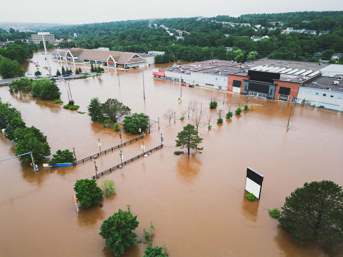
This covered 23 river basins including 1,700 catchments and was configured as a Web Map Service. FloodMapp supported QFES over that summer with real-time, highly accurate flood mapping for use in the State Disaster Coordination Centre during flood events.
On 17 March 2021 the township of Sapphire in Central Queensland suffered a significant flooding event, with Retreat Creek rising 10m in a matter of hours. The local flood warning system in the town failed to sound and so residents awoke to major flooding with little warning. Moreover, as the town is remotely located and without strong mobile signals, emergency services were largely unaware that the town was in a potentially serious flood event.

On the morning of the flood event, QFES received a call from someone in distress saying that their home had been flooded to the roof and they needed emergency assistance.
Poor mobile coverage meant QFES lost contact with this person part way through the call. The full circumstances had not been established and they were unsure what type of service was required, for example: was a rescue helicopter rescue required to lift the person from a rooftop.
FloodMapp NowCast provided real time mapping of the flood extent and depth. As QFES had pinpointed the location of the failed call, the FloodMapp real-time inundation mapping data was used to overlay the location of the call.
With this real-time situational awareness Queensland emergency responders were able to quickly determine that the caller was well away from the floodwaters and could be accessed and recovered by road.
This vital intelligence in real-time enhanced decision making and ultimately saved tasking a specialist rescue helicopter when none was needed. The rescue helicopter then continued to be available for high priority tasking and saved significant time and cost.

The value of FloodMapp Nowcast in providing QFES with vital situational awareness of the flood impact in real-time was crystal clear. Data driven decision making removed significant uncertainty. The real-time modelling provided successfully underpinned the most efficient, effective and safest dispatch solution for emergency services. This use case type can be replicated and delivered at scale on a statewide basis.
Importantly, in this example FloodMapp modelling operated in an area where no Flood Study had ever been undertaken. On the ground validation demonstrated Floodmapp performed with a high degree of accuracy.
NowCast is powered by FloodMapp’s proprietary real-time and scalable hydraulic modelling system DASH. DASH works by ingesting tidal and river height data from partners including the Bureau of Meteorology and Department of Natural Resources (Queensland). This then powers NowCast to compute hydraulic models at the highest resolution available up to 1m across an area. NowCast generates updates of flood extent data as a raster format, and is available as an integration on ArcGIS online. In this example models are updated hourly as this is when river gauge data is refreshed.


I was looking for details about, and this article explained the registration process in a simple and easy-to-follow way. The step-by-step information is helpful for anyone creating an account for the first time. I also liked the safety tips included in the post. Thanks for sharing such a clear and informative article—it was really useful. DMWin Game Register
After reading this, I found the data presentation fairly straightforward, though I still had some uncertainties. I noted the quick updates, but I remained cautious about the source. I spent some time poking around https://fr.trustpilot.com/review/casinoretraitrapide.com and overall it's laid out neatly. The article’s focus on real‑time modeling is useful, but I would like to see more corroborating references.
This is one of the best guides I've read recently. The content is informative, easy to understand, and written in a friendly tone. I found all the answers I was looking for in one place. Thank you for making the topic so simple. I hope you continue publishing more helpful articles.
lottery7 game
After reading through this post, I appreciated how real time flood modelling was explained in a simple and understandable manner. The examples helped connect the technology with real world situations. It reminded me of the clear communication style found around sellmyhouseinbrevard.com where practical decisions are made easier through straightforward information. This was both informative and enjoyable to read.
Exceptional overview of why proactive flood forecasting is so valuable for protecting communities and improving emergency planning. The explanations are practical and highlight how preparation can reduce long term risks before disasters occur. I recently came across a discussion on https://coselite.com/ about presenting complex topics in a straightforward manner, and this article reflects that same attention to clarity. Educational resources like this help readers better understand important real world challenges.