
ForeCast: The Key to Proactive Flood Preparedness, Management, and Protection
- May 8, 2025
- 5 min read
Updated: Jul 10, 2025

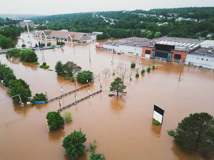
Flooding is a rapidly evolving hazard, and when every second counts, predicting flood impacts before they happen can transform how emergency managers respond. In recent years, the frequency and severity of floods have increased, making it more challenging for emergency managers, utility providers, and local governments to effectively plan for and respond to these events. Floods are a major public safety risk, taking lives every year. Approximately half of all flood fatalities occur on our roads. Furthermore, the financial toll on communities and businesses is immense, with infrastructure damage, service interruptions, and recovery efforts requiring costly resources.
The lack of localized and timely situational awareness of flood impact on people, property, and critical infrastructure often leaves communities vulnerable to the worst impacts of flooding. That’s where operational, impact-based flood forecast systems come in—delivering emergency managers, asset owners, and communities actionable intelligence and allowing organizations to make proactive, data-driven decisions that can save lives, protect infrastructure, and reduce economic losses.
In this blog, we’ll explore how FloodMapp’s ForeCast tool can help you mitigate these risks and prepare for hurricane season.
The Growing Need for Real-Time Flood Forecasting
Flooding events can happen suddenly and without much warning. Emergency managers must decide on evacuations, resource allocation, and public safety in the face of unpredictable flood events, often with little time to make critical decisions.
FloodMapp’s ForeCast is a tool designed to provide predictive, impact-based flood forecasts that help emergency responders make informed decisions. By integrating the best available data from multiple sources, including rainfall, stream gauges, and river height data, ForeCast provides accurate flood forecasts 6 to 72 hours in advance, enabling organizations to act early and effectively.
Flood Forecasting Explained
ForeCast leverages FloodMapp DASH to provide live predictive flood intelligence with unmatched accuracy, utilizing operational hydrology forecast models to predict peak flood height and rapid operational hydraulics models, which go a step further to predict subsequent flood inundation extent, depth, and impact. These models use a comprehensive set of inputs.
Hydrology
The operational hydrology ForeCast models leverage antecedent, observed, and forecast rainfall to understand how saturated the catchment is and how it is likely to respond with additional rainfall. They also use catchment characteristics such as catchment size and river cross section, and river height data. An example of an operational model is shown below for the Thompson River at Stonehenge QLD during the recent Western QLD floods.

Rapid Hydraulics
FloodMapp’s rapid hydraulics model leverages the best available digital elevation model (DEM) data and the stream and river network to construct the model domain. The models are driven by real-time data from all available gauges, including federal networks such as BoM, USGS, NOAA, NWS, and state and local gauge networks, to form model boundary conditions and calibrate simulated flood levels at each gauged location.

Sometimes during a flood, flood gauge readings may become unavailable, which may be due to the flood gauge becoming damaged or washed away, or a problem with the telemetry, meaning that data logging goes offline. Machine learning can be particularly valuable for training models to learn how a gauge will likely respond during an event with the other gauges in a network. It can support identifying missing data and predicting and infilling it based on the trained model. An example of this is shown below.
ForeCast is updated every hour, continuously incorporating new data from river gauges and updated precipitation forecasts, ensuring that FloodMapp's flood predictions reflect the most accurate, up-to-date information. When weather bureaus revise their outlooks, ForeCast quickly incorporates those changes to maintain alignment with other data sources and improve decision-making.
Putting it all together, implementing an impact-based forecasting system can be used to forecast localized flood impact by enhancing flood height predictions with forecast inundation extent, depth, and impacts. This can support emergency managers and asset owners in understanding which people, homes, and critical assets are at risk of impact before a flood happens. The animation below shows ForeCast for Hurricane Helene in the Town of Narrows, Giles County, Virginia. You can see the operational forecast in action to predict the flood height 6 hours in advance, and the corresponding flood impact on homes and roads, which can be vital to inform evacuations, road closures, and asset protection.
ForeCast—along with the rest of FloodMapp’s product suite—is delivered as data-as-a-service through an API, which means it seamlessly integrates into your existing GIS systems as an additional layer. This allows users to easily incorporate real-time flood intelligence directly into their workflow, enhancing the value of existing tools.
The combination of ForeCast with NowCast, which offers real-time data during the flood event, provides a powerful decision-support system. While NowCast offers real-time data during a flood event, ForeCast allows users to see the predicted flood extent and depth hours in advance, helping users make proactive decisions and take preventive action before the worst impacts occur. By integrating with other GIS data, ForeCast allows for a more comprehensive view of the flood’s potential impacts on infrastructure, roads, and buildings, making it an invaluable resource for emergency managers, utilities, and local governments.
As an added value, ForeCast offers the ability to create customized alerts based on specific flood thresholds. This feature ensures that key stakeholders receive timely notifications whenever the forecasted flood level exceeds the defined threshold. Users provide a GIS layer, along with the desired flood thresholds, and will receive an email and SMS alert whenever the water levels are forecasted to exceed the given threshold. Clients already rely on these alerts to help minimize disruptions and enhance their operational response to flood events.

Our cloud-based infrastructure ensures ForeCast remains robust and scalable, handling large areas and delivering consistent results every hour. For instance, FloodMapp currently provides coverage for Queensland, Australia—a region two and a half times the size of Texas.
ForeCast’s infrastructure ensures 99.5% uptime, even when equipment is damaged during extreme flooding events. If river gauges are knocked out, FloodMapp’s interpolation system fills in missing data, ensuring uninterrupted forecasting. We also collect data from multiple meteorological sources, ensuring reliability even if one provider's infrastructure is compromised.
What Users Can Achieve with ForeCast
With ForeCast, emergency managers, utilities, and local authorities can access detailed, up-to-the-minute flood data to optimize their decision-making process and better prepare for future events.
Seamless GIS Integration: ForeCast integrates directly into your existing GIS system, allowing for a streamlined workflow without requiring new platforms or complicated processes. This integration ensures you can use the data you already rely on, while adding valuable flood intelligence to guide your decisions.
Scalability: Whether you’re focusing on localized flood risk assessments or managing flood forecasting for a larger region, ForeCast is designed to scale to your needs. For example, FloodMapp’s system covers vast areas like Queensland, Australia—demonstrating the capability to handle large-scale flood events in complex regions.
Customizable Alerts and Dashboards: Users can tailor alerts based on specific flood thresholds, ensuring that critical stakeholders receive timely notifications. Alerts are sent via email or SMS, ensuring that the right people are informed as soon as potential threats are identified. Additionally, the dashboards can be customized to display the most relevant information for emergency managers, utility operators, and other decision-makers, enabling faster response times and better resource allocation.
Real-Time Decision Support: ForeCast provides actionable insights on flood data, allowing emergency responders to stay one step ahead of a flooding event. Whether it’s protecting critical infrastructure or making key evacuation decisions, FloodMapp’s real-time data helps you take immediate action to reduce risk and minimize damage.
Empowering You with Real-Time Flood Intelligence
Flooding is one of the most dangerous natural disasters that communities face, and early action is crucial to minimizing its impact. FloodMapp’s ForeCast provides predictive intelligence that enables emergency managers and utilities to act ahead of time, saving lives and protecting infrastructure.
With ForeCast, organizations can stay one step ahead of flood risks by gaining early insights into flood conditions. The ability to make data-driven decisions before, during, and after a flood event can significantly reduce the economic and human impact of flooding.
We invite you to learn more about how ForeCast can be integrated into your operations to improve flood preparedness and response. Schedule a demo today to explore its full potential.


The detail that half of flood fatalities happen on roads really struck me, and the system's hourly updates using river gauge data show how dynamic forecasting is. It's like checking my forge calculator roblox before a big game session-both tools turn complex data into actionable plans, making me wonder how such tech could be part of our daily weather apps too!
This post clearly explains why forecasting is essential for proactive flood preparedness and risk https://allknight.com/ management. The insights are timely and practical. we appreciate content that combines technology, planning, and awareness to support safer communities.
This article effectively explains why forecasting is essential for proactive flood preparedness and risk https://3yhealth.com/ management. Timely data can save lives and resources. we support forward-thinking approaches that protect communities, improve resilience, and promote environmental safety.
Very informative https://alphadentalexcellence.com/ and timely article. The emphasis on proactive planning is well explained. I came across a similar risk-management discussion on an alphadentalexcellence-based blog that highlighted preparedness too.
Very informative https://www.jimandsonsplumbing.com/ and timely. I appreciated how actionable the insights were, especially for planners and communities, similar to the practical breakdowns I’ve seen on a jim and sons plumbing review blog.