
Hurricane-Ready: 5 Flood Response Essentials Every Emergency Manager Needs This Season
- Jun 10, 2025
- 2 min read
Updated: Jul 10, 2025
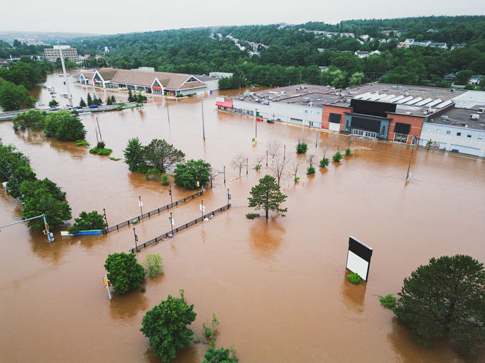
Hurricane Helene was catastrophic and caused an estimated $30.5 billion to $47.5 billion in damages. What you may not realize is that up to 86% of this damage ($26 - $41 billion)1 was caused by flooding, including coastal storm surge, riverine flooding, and flash flooding from intense rainfall.
As hurricane season intensifies, so does the pressure on emergency managers to stay ahead of destructive storms. Coastal and inland communities alike are facing increased flood risks due to recurring severe weather events, aging infrastructure, and complex logistics.
This year, agencies are stepping up with modern tools and advanced strategies. Below, we break down the top 5 actions emergency managers are taking to get hurricane-ready, and how live and predictive flood intelligence supports each step.
1. Identify At-Risk Areas with Predictive Flood Modeling
Knowing where flooding is most likely to occur is the first step toward effective preparation. With FloodMapp ForeCast, agencies can visualize street-level flood impacts 72 hours before the event starts.
ForeCast helps you:
Pinpoint flood-prone roads, neighborhoods, and critical infrastructure
Disseminate targeted alerts and warnings
Prioritize evacuation planning
Protect sites and mitigate flood damage to assets
Allocate response resources more efficiently
2. Plan and Communicate Evacuation Routes
Once you know where the water is going, the next step is routing people and crews safely during the flood event. NowCast to help you:
Identify flood-safe routes for emergency responders
Gather and maintain dynamic situational awareness on impacted roadways
Send localized and personalized alerts to communities at risk
Whether integrated into Waze for live traffic routing, your Esri dashboard, or shared with custom alerting platforms (such as Genasys), FloodMapp supports more informed, faster decisions when there is no time to waste.

3. Position Response Resources Strategically

Strategic staging of personnel and supplies can make or break a response effort. With hourly updates from NowCast, your field crews and swift-water teams stay informed about:
Real-time flood movement
Road access and closures
Safe zones for staging and response
This insight helps optimize high-clearance vehicle routes, sandbag deployments, and emergency shelter access. Most importantly, it helps keep your teams safe in the field.
4. Coordinate in Real Time with Live Dashboards
Flood conditions evolve rapidly. With FloodMapp, you get dynamic flood data delivered directly to your existing systems.
Benefits for your EOC and agency partners:
Unified situational awareness
Custom alerts for rising water and critical thresholds
Scalable common operating picture across departments
5. Accelerate Recovery with Post-Flood Intelligence
FloodMapp’s PostCast gives you rapid access to high-resolution flood depth and extent maps and data, without waiting for satellite imagery or on-the-ground surveys.
Use it to:
Assess damage quickly and accurately
Understand how many homes or assets have been impacted, and in which regions
Inform grant program submissions to access disaster recovery funding
Prioritize repairs and clean-up efforts
PostCast helps your agency transition from response to recovery in record time.

Be Hurricane-Ready with the Right Tools
In emergency management, preparation isn’t a checklist—it’s an operational system. FloodMapp empowers your agency to act sooner, respond smarter, and recover faster with flood intelligence built for real-time decision-making.
Request a demo to enhance your flood toolkit.


What a refreshing and well-written piece! Read the full article I really appreciated how thoroughly you covered this topic and presented such balanced perspectives. Thanks for keeping us informed with quality journalism like this!
Absolutely fantastic piece! 소액결제 현금화 This is exactly the kind of thoughtful, well-researched reporting we need more of. Really appreciate you bringing this important story to our attention!
Excellent piece! 정보이용료현금화 I really appreciated how thoroughly the author covered all the angles on this topic. This is exactly the kind of balanced, informative reporting we need more of!
Fantastic piece! 소액결제 현금화 I really appreciate how thoroughly you covered this topic and presented such a balanced perspective. Your writing style makes complex information easy to understand, and it's exactly the kind of quality journalism we need more of!
Excellent reporting! This piece really breaks down the story in a clear and accessible way that helps readers understand the bigger picture. 정보이용료 현금화 Keep up the fantastic work!