
The Power of Live Mapping Feeds
- Feb 16, 2023
- 2 min read
When clients ask, “What will the forecast rainfall look like as a flood extent?” or “How will the predicted peak river level play out?”, FloodMapp products provide an understanding of what the flood extent could look like, the current situation, or what it looked like in the past 30 days. We show that via layers on a map - Web Map Services (WMS) and Web Feature Services (WFS).
But what is WMS and WFS? And how can they support operational situational awareness during a flood event? First, we’ll start by explaining the difference between WMS and WFS. Though similar, both formats have different capabilities and use cases.
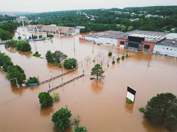
In a FloodMapp context, WMS provides a visual representation of riverine, overland, and coastal flooding that can be overlayed on a map to show both extent and depth. Using FloodMapp’s NowCast product as a WMS layer, for example, will show clients what the flooding looks like on the ground in real time as an image on a map, as pictured below. The data is quick to render which means it’s quick to draw, load and use.

WMS: Displaying complex data as an image to improve performance.
WFS, however, offers extra capabilities compared to WMS.Where WMS is a visual representation of the flooding, WFS provides greater and more detailed use as clients have direct access to the raw vector data which allows clients to run analysis on the polygon. In a FloodMapp context, that may involve intersecting properties or critical infrastructure within the polygon (for example, flood extent polygon), as pictured below, to run analysis on the predicted, current or previous flood impact. However, this format is more complex and the data comes at the cost of slower processing times.

WFS: Running analysis to intersect the flood extent polygon with building footprints (red outline).
Clients receive FloodMapp products in both WMS and WFS formats but can swap between the two based on their business needs. Do I need to overlay the flood extent on a map so management can clearly and quickly understand and visualise the impacted areas? Do I need to run analysis to answer specific, detailed questions? The responses to these questions will determine the best format to use.
Accurate, real-time flood intelligence allows emergency managers and their teams to work from a common operating picture and supports public messaging, risk mitigation, impact analytics (predictive or actual) and the deployment of field crews. This is another benefit of delivering real-time situational awareness as WFS and WMS via Application Programming Interface (API), as both formats can be added as a layer to new or existing maps to enrich and add value to client data and provide a common operating picture across the organisation.
Time is a major, crucial component for emergency managers. FloodMapp’s NowCast product updates hourly, so it’s vital to match modelling speed with data access and processing time so clients can see the situation, interact and adapt in real time. The flexibility of using a WMS or WFS, depending on specific needs, supports time sensitive decision making by our clients.
If you’d like to learn more about how FloodMapp’s WMS and WFS layers can support operational situational awareness for you, please email sales@floodmapp.com


Customizing my athlete in speed stars has been such a fun part of the experience! Earning gems through races and unlocking new shoes, socks, and arm styles makes every victory feel meaningful.
Fantastic piece! 소액결제현금화 This is exactly the kind of thorough, well-researched reporting we need more of. Really appreciate you breaking down such a complex topic in such an accessible way!
Compared with other browser driving games, Drive Mad free feels much more skill-based. It’s less about speed and more about learning how the vehicle reacts on strange terrain.
Lately, I was searching for a reliable instagram reels download tool that works without installing any application. After trying a few different websites, this one worked surprisingly well for me and the process felt very simple.
What stands out here is how live mapping feeds go beyond just displaying information—they actually support real-time decision-making by giving teams a constantly updated, shared view of what’s happening on the ground. The distinction between faster visual layers and more detailed data layers also shows how important it is to match the tool to the situation, especially during events like floods where timing is critical. That balance between clarity and responsiveness is really powerful, and in a much simpler, everyday way, it reminds me of how even basic visual activities—like the ones I’ve seen on https://zdarmaomalovanky.com/ —can also help improve focus and how we process information.