
Floodplain Fundamentals
- Dec 13, 2022
- 5 min read
For part three of our series on flood warnings, floodplain behaviour and emergency management framework, we’ll be looking into the fundamentals of flooding and exploring the different ways flooding may occur.
The mechanisms that may cause flooding can be broken down into three concepts:
Sources of flooding
Rainfall (intensity, duration and distribution)
Catchment types and behaviour.
Sources of flooding
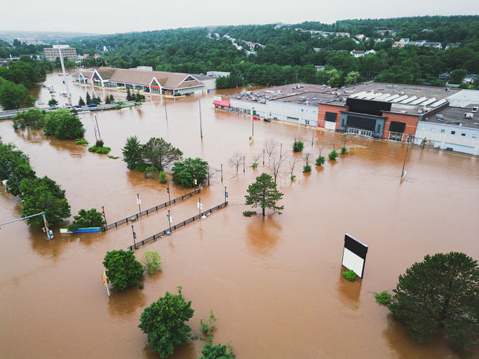
The sources of flooding can be broken into three main types:
Runoff from rainfall - which travels over ground to waterways such as gullies, creeks and rivers. This is sometimes referred to as “overland flow” in local government flood mapping.
Creek or river flooding - where rising water overflows banks and causes inundation of surrounding land.
High tides or storm surges - causing inundation of surrounding low-lying coastal areas.

Figure 1: Factors that contribute to floods (Office of the Queensland Chief Scientist, 2022)
It is possible to have multiple sources of inundation during a flood event
Flooding from dam overflow, water flowing out of stormwater pits, blocked drains or culverts are all factors which may result in flood inundation.
Understanding the different sources of flood inundation is an important step in understanding your flood risk and therefore, being able to better prepare and respond.
Click here to watch a Bureau of Meteorology video that explains the different types of flooding. If you would like to learn more, there is also a useful summary provided by the Queensland Chief Scientist here.
Does flooding only occur during a one-in-100-year flood?
Flooding can occur anytime rainfall causes runoff that exceeds drainage infrastructure or capacity of gullies, creeks and rivers.
First, let’s discuss event probability.
The term ‘one-in-100-year’ flood event is not a flood that occurs once every 100 years. Rather, it is an event that has a 1/100 or a 1% chance of occurring or being exceeded in any one year. We refer to this concept as a 1% annual exceedance probability (AEP).
It is certainly possible to have a 1% AEP event occur in consecutive years. The risk reference means it is calculated there is a 1% chance that an event of that scale may occur or be exceeded in any one year.
Also, a 1% AEP event is not an assessment of likely flood damage or impacts. Depending on the nature of the built environment, assets, or infrastructure in a community or locality, less significant but more frequent events may still cause inundation, be disruptive and require management and action.
What causes flooding?
Rain! The determining factors of whether rain will cause a flood depends on the:
Intensity of the rainfall – how much rainfall fell over time.
Duration of the rainfall – the total volume of which fell.
Rainfall distribution – The area where it rained.
An easy way to think about this is, if 100mm of rain falls in one hour, the amount of runoff (and risk of floods occurring) is significantly more than if 100mm falls over two days.
For example, as shown in Figure 1, a rainfall event of just 10mm has the potential to be a significant (1% AEP event or 1% chance of occurring in any one year) if the 10mm of rain falls in 10 minutes.
However, if the same 10mm of rain falls over two hours, instead, then this is aligned with a less significant and more frequent rainfall event (50% AEP event or 50% chance of occurring in any one year) and may not cause flooding.
This is further complicated by how wet a catchment may already be (from prior rainfall events) and much of the catchment is affected by this rainfall event.
There are many variables at play at the same time. There is no simple calculator that can convert rain to a flood.

Figure 2: Intensity - Frequency - Duration (IFD) example (BOM, 2022)
Different areas will have a different reaction to rainfall, depending on location, the landscape, and the build environment.
For example, steep areas near the top of a hill or mountain are typically more affected by short sharp rainfall events (flash flooding) while flat floodplains are more impacted by long consistent durations of rainfall.
In essence, this is because of the time it takes for floodwaters to travel from the top of the catchment to where we are interested in the impact.
Areas at the top of the catchment may be impacted in minutes to hours, whereas the bottom of the catchment, closer to the ocean for instance, may be hours, days, or longer.
It all depends on the distance from where the rain fell and the time taken to get to the bottom of the catchment.
How does this fit into flood predictions?
Flash flooding typically occurs at the top of the catchment, where there is a short timeframe between when the rain has fallen and the flood water reaching its peak.
The Bureau of Meteorology doesn’t issue flood forecasts for creek or river levels for this type of floods as it is difficult to collect data and forecast the flood levels within a timeframe that can provide adequate warning.
As local governments and the SES have more localised knowledge, they issue flood predictions for catchments with response times of less than six hours, as explained in our previous blog.
That being said, it is still difficult to predict flash flood levels due to elements such as rapidly changing weather, catchment conditions (saturated or dry), or overflows from dams and drainage infrastructure.
Lower down in the catchment, where the response time is greater than six hours the Bureau provides forecasted flood levels at identified stream gauges.
Specific flood predictions are difficult to derive, especially for flash flood events and as rainfall systems are dynamic and can rapidly change.
Summary
In summary, the emergency management framework is an escalation-based system where increases in impact and intensity results in an escalation through levels of government. The key is that each level of government has responsibility which is match to its capacity, capability and applicable legislated requirements.
As such, in Australia local governments and SES (depending on state jurisdiction) have primary responsibility for flood events as they have the capacity and capability to respond to events within the local area. As events become more significant and exceed capacity, capability or affects multiple geographic areas, then support may be requested and be escalated through State and Federal government.
How the response will be escalated from local, through to the federal response is dependant on local capacity, event size, intensity and complexity.
Flood watches and flood warnings have a critical role in understanding the potential areas which may be affected, and how the size, intensity and complexity of the event may unfold. The type of rainfall event and flood behaviour mechanism for the affected catchments (i.e. overland flow, flash flooding, riverine flooding) provides critical information on which emergency management agency has responsibilities to provide support before, during and after a flood event.


https://luck80.net/ dạo này thấy bạn bè nhắc hoài nên mình cũng bấm vào nghía thử cho biết. Mình không đọc kỹ nội dung bên trong đâu, chủ yếu xem giao diện với cách họ bố trí trang thế nào thôi. Vừa vào là thấy kiểu sắp xếp khá dễ chịu, nhìn không bị ngộp chữ hay rối mắt. Mấy phần nội dung được chia thành từng khối rõ ràng nên kéo xuống tới đâu là biết mình đang xem mục nào, không phải đoán. Mình cũng thích cái cách họ trình bày thông tin theo kiểu gọn gàng, nhìn lướt vẫn nắm được ý chính. Menu đặt chỗ dễ thấy nên chuyển qua lại cũng nhanh, không phải mò mẫm…
https://keonhacai5.net/ dạo này thấy nhiều người nhắc nên mình cũng bấm vào nghía thử cho biết. Mình không đọc sâu gì đâu, chỉ lướt nhanh xem giao diện có dễ nhìn không. Cảm giác đầu tiên là trang làm khá gọn, nhìn vào không bị rối, kiểu chia từng khối nội dung rõ ràng nên mắt bắt nhịp nhanh. Mình để ý mấy bảng dạng cột họ trình bày nhìn sạch sẽ, kéo xuống vẫn dễ theo dõi chứ không bị dàn trải lung tung. Menu thì đặt chỗ khá dễ thấy, chuyển qua lại vài mục cũng nhanh, không phải mò nhiều bước. Nói chung lướt vài phút thấy ổn vì bố cục chia khu vực rõ và các…
xoilac mình thấy nhiều người nhắc nên tò mò bấm vào xem thử giao diện thế nào. Mình không có ngồi soi nội dung hay chơi gì cả, chỉ lướt qua cho biết cách họ sắp xếp trang thôi. Cảm giác đầu tiên là bố cục khá dễ nhìn, kiểu chia thành từng khối nội dung rõ ràng nên kéo xuống không bị ngợp. Mình thích nhất là phần menu đặt chỗ dễ thấy, bấm qua lại giữa các mục khá nhanh, không phải tìm vòng vòng. Mấy bảng thông tin cũng trình bày theo cột gọn gàng, nhìn cái là nắm được ngay chứ không rối mắt. Nói chung lướt vài phút là hiểu họ tổ chức trang ra…
337bet caiu no meu radar esses dias e eu entrei mais por curiosidade pra ver como era a cara do site. Não mexi em tudo, mas de primeira já achei bem tranquilo de usar: o menu não fica escondido e dá pra pular entre as partes sem aquela sensação de “onde é que eu clico agora?”. Também curti que eles não entopem a tela com um monte de coisa ao mesmo tempo, parece que organizaram tudo em blocos bem certinhos, então você bate o olho e entende o que é o quê. Pra quem só quer se localizar rápido, ajuda bastante e não cansa. No geral, a impressão foi de um layout limpo, com categorias separadas em caixas áreas bem…
789bet mình thấy mấy đứa bạn nhắc suốt nên hôm trước rảnh bấm vào coi thử cho biết thôi. Không phải kiểu ngồi nghiên cứu trò này trò kia đâu, mình chỉ tò mò xem giao diện có dễ nhìn không. Vào cái là thấy trang làm khá gọn, khoảng trắng vừa đủ nên không bị ngợp, lướt xuống cũng đỡ mỏi mắt. Mấy mục được chia theo nhóm nhìn phát hiểu luôn, kiểu mình biết đang ở phần nào mà không cần dò lại. Mình thích nhất là cách họ trình bày dạng khối với danh sách, nhìn nhanh mà vẫn rõ, nhất là mấy chỗ thông tin để theo kiểu bảng cột nên đọc số liệu dễ hơn.…