
Responding to seven feet of rain
- Dec 22, 2023
- 2 min read
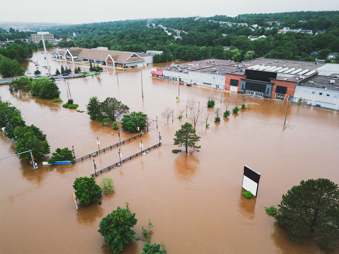
On December 13, 2023 Tropical Cyclone Jasper crossed the Queensland Coast at around 8:00PM as a Category 2 event. While local communities responded well to the Tropical Cyclone and the wind it brought with it, intense rainfall accompanied TC Jasper and continued to fall over a wide area. Some locations have experienced over two metres (around seven feet) of rain. Major flooding occurred quickly, and over a large area. This severely impacted areas such as Cairns, Daintree Village, Mossman and Wujal Wujal – inundating homes, damaging roads, and cutting access to power, remote communities, a hospital and even a major airport.

Earlier this year we wrote about the current El Nino phase and the fact that despite assessments of lower risks floods can and do occur. Headlines at the start of 2023 proclaimed Australia could swing from three years of La Niña to hot and dry El Niño. The reality is, we have just seen record breaking rain and flooding, and this is further evidence that extreme flood events can happen irrespective of the phase of ENSO cycle. We must always be prepared for severe weather and flooding. And in a changing climate, we need to expect the unexpected.
FloodMapp provides live flood impact mapping services to the Queensland government, and both public and private critical infrastructure owners. Our ForeCast, NowCast and PostCast services are ingested as live digital feeds into an esri ArcGIS Enterprise platform. FloodMapp’s services support live situational awareness on the potential impact to people, property and critical infrastructure, delivered at state-wide at scale. The live flood intelligence feeds, maps and accompanying data enable key combat agencies to work in concert with weather agencies (BoM) and across many functions and all levels to government to plan, respond and recover from flood events. When the primary focus of emergency agencies is to keep people safe and reduce damage the speed of situational awareness is vital. TO support this access to FloodMapp data enables:
Creation of a live profile of flood extents at State-wide scale;
The ability to identify and target areas of major flood risk;
Creation of dynamic situational profiles;
Modelling flood consequence in real time - to plan, monitor and adapt; and
Immediate aggregation and assessment of flood impacts.

The second key benefit of live mapping is it enables collaboration with emergency authorities and to share live data from the ground.
Live sharing enables FloodMapp to rapidly consume images, damage assessments, request for assistance etc from the impact area to continuously review and validate model performance.
Collaboration is critical to creating the feedback loops from ‘on the ground’ data to link to rapid validation and continuous improvement.

FloodMapp’s delivery of live mapping of floods to emergency authorities is changing the way we can understand the extent, consequences, and impacts of flood events. Building on this to create a two-way feedback loops - live situational awareness at state-wide scale with real time impact feedback is now a reality. This live situational intelligence on impact to people, property and critical infrastructure has proved vital for informing the Premier and the Prime Minister on the situation as it unfolded, to support a rapid response and recovery with targeted distribution of resources.

We can now rapidly capture, analyse, and validate quality data and deliver our vision to solve the wicked emergency problems – citizen safety and reduced damage.


Great piece! This is exactly the kind of insightful reporting we need more of—really well researched and presented in such a clear way. Find out more Thanks for keeping us informed!
Fantastic reporting! This article really breaks down the topic in such a clear and accessible way. 소액결제현금화 I appreciate the thorough research and balanced perspective – exactly what quality journalism should look like!
Fantastic reporting! 소액결제현금화 This piece really breaks down the issue in a way that's easy to understand and engaging from start to finish. Thanks for keeping us informed with such thoughtful journalism!
What an inspiring story! This is exactly the kind of positive news we need more of—it really shows the best in people. 정보이용료현금화 Thanks for keeping us informed and uplifted!
Fantastic piece! This is exactly the kind of thoughtful, well-researched journalism we need more of. 정보이용료현금화 Really appreciate the effort your team put into bringing this story to light!