
What's Included


Custom Dashboard Features
Everything you need, in one place.
From road or building impacts to post-event damage assessments, see the information you need —when you need it.


What You Can Do
During • After
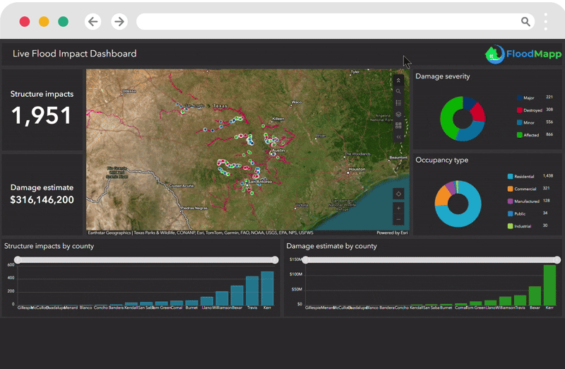
As conditions change hour by hour, can your teams see the live flood impact, monitoring extent and depth to adjust closures and access? FloodMapp RESPOND turns live data into street-level inundation and depth in your GIS, delivering localized intel to help you:
During
Identify affected areas, roads and assets; track the evolving footprint; adapt closures and rescue routes; align agencies on a common, GIS-based operating picture.
See it for yourself
Hourly Operational View
Live Operations +
Rapid Damage Assessment
NowCast maps hourly extent, depth, and impact, while PostCast preserves the event’s maximum footprint—so you can time reopenings, prioritize resources as waters recede, and document damage with confidence.

Best Fit For
Public safety and emergency management, transportation operations, recovery teams, field and network operators, and organizations responsible for protecting people and assets across multi-site footprints, communities, and regional networks in the USA and Australia.
Made for Teams That...
Require a high-resolution, live map during an active flood
Issue targeted alerts during and after flood events
Direct closures, evacuations, and rescues
Monitor which communities, roads, and assets are impacted
Prioritize post-event recovery and PDAs immediately


Tiers, Coverage & Programs
Choose the solution that matches your needs. All packages deliver GIS-native live layers; tier differences focus on coverage, access, refresh options, and support.


(3 Steps)
How It Works
-
Connect: Access FloodMapp's live mapping feed.
-
Update: Overlay FloodMapp layers in your GIS platform to assess localized impact.
-
Share: Update your community in advance with confidence.


