

Background
In early July 2025, catastrophic flash flooding was unfolding across more than 22 counties in Texas Hill Country when FloodMapp was integrated into the Texas Division of Emergency Management’s (TDEM) response operations.
Localized, intense rainfall triggered rapid river rises, some locations saw water levels increase by more than 26 feet in under an hour. The event escalated largely overnight, creating a fast-moving multi-jurisdictional emergency.
During active response operations, TDEM needed more than rainfall forecasts and river gauge readings. They needed a live, structure-level view of flood impact across the state.
FloodMapp was deployed mid-crisis to deliver exactly that.

The Challenge

Statewide Impact Dashboard view showing structure-level impacts across 22+ counties during active response operations.
Signals to Situational Intelligence
As the event unfolded, emergency managers were working with:
-
Rainfall forecasts that describe how much rain may fall, not where flooding may occur or what it may impact
-
River height forecasts that provide point-based information, often disconnected from local impacts
-
Satellite imagery and aerial observations that typically become available after peak flooding
Flooding was occurring simultaneously across more than 22 counties. There was no single, consistent, statewide view of impact that could be relied upon in real time.
The Approach
Real-Time Flood Impact Intel, Deployed Mid-Crisis
FloodMapp was integrated into TDEM’s workflows while response operations were already underway.
Using forecasted rainfall and available stream gauge data, FloodMapp provided GIS-ready layers that aligned with existing tools and workflows:
-
NowCast: Hourly flood inundation extent and depth
-
PostCast: Rapid post-event flood reconstruction to support damage assessment
These outputs and dashboards were shared with state, local, and federal partners immediately, helping teams align around a common operating picture without disrupting ongoing response efforts.
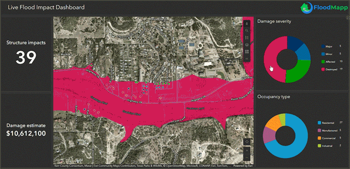
Zoomed-in view illustrating structure-level impact and severity classification used to support prioritization and resource allocation.
What This Enabled
With a consistent, structure-level view of impacts across jurisdictions, TDEM and its partners were better positioned to:
Rapidly identify counties and communities experiencing the most severe impacts
Guide search-and-rescue teams to areas requiring priority attention
Consider road access and closure needs
Communicate evolving conditions to leadership and partner agencies
Prioritize resource allocation to the most affected communities
Rather than replacing existing systems, FloodMapp reduced uncertainty and manual data assembly at a time of peak operational demand, providing trusted intelligence that supported coordinated action.
The Outcome
From Response to Recovery
As immediate life-safety operations continued, attention began to shift toward recovery planning.
FloodMapp’s PostCast and Impact Analytics provided early insight into:
-
Areas that have experienced the greatest impacts
-
Affected roads, properties, and infrastructure
-
Where follow-up recovery efforts will be needed once access is restored
Having this information available early, rather than weeks later, helped teams begin planning recovery activities while response operations were still going.

FloodMapp's Impact Analytics Dashboard visualizes structural impacts and estimated damages.
Why This Matters
The July 2025 Texas floods were a devastating event with lasting impacts on families and communities.
While no technology can change that reality, the response demonstrated the value of live, operational flood impact intelligence that can be deployed rapidly and maintained throughout a crisis.
This experience shows how real-time flood intelligence can:
-
Support coordination action across state, local, and federal partners
-
Enable earlier, defensible preliminary damage assessments
-
Reduce manual data burden during peak response
-
Accelerate delivery of recovery resources to affected communities


Download the Full Case Study
Explore the complete analysis, validation results, and ground-truth comparisons from the July 2025 Texas floods.

.jpg)


