
How Operational, Impact-based Flood Forecasting Enables Resilience
- Nov 12, 2025
- 3 min read
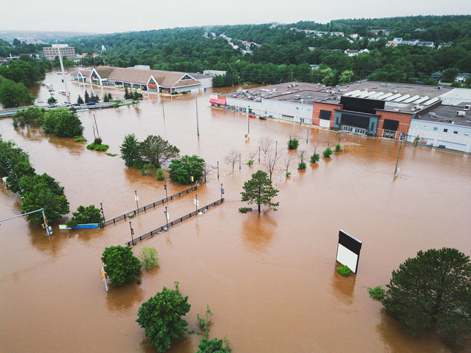
Australia’s wet season is approaching, and the latest outlooks from the Australian Bureau of Meteorology (BoM) may significantly elevate the risk of flooding across the eastern two-thirds of the country. For state and local emergency management agencies, this means planning ahead is not optional. Catchments already saturated, shifting climate drivers, and overlapping hazards now demand a proactive, intelligence-led approach.

“Flooding continues to be one of Australia's most frequent and costly natural disasters… For councils, the message is clear: floods won't go away. They disrupt lives. They test preparedness. They demand strong coordination across agencies.” — Gregory Lopez, Esri Australia
According to the BoM’s long-range outlook for November 10 – 23, there is up to an 80% chance of exceeding median rainfall for Northern Australia, Eastern Australia, and parts of Western Australia. This means that we could enter the wet season with wet catchments, which could significantly exacerbate flood risk.
For November-January, there is a 60-80% chance of above-average rainfall for eastern Queensland, much of New South Wales (NSW), Northern Victoria, and eastern Tasmania.

Meanwhile, the Australian Government’s National Emergency Management Agency (NEMA) designates October–April as the “Higher Risk Weather Season”, when bushfires, tropical cyclones, and flooding all increase in likelihood.
These combined signals raise important considerations for emergency managers and public safety officials:
More frequent and intense rainfall events early in the season
Greater potential for flash flooding and riverine flood responses
Overlapping hazards that amplify risk

It’s worth noting that long-range forecasts aren’t foolproof. According to BoM’s past accuracy data (pictured above), results vary widely by region, from 0% up to about 70%. In other words, while seasonal forecasts are useful planning tools, emergency managers should stay ready for both drier and far wetter conditions than expected.
Key Challenges for the Wet Season
Saturated Catchments & Reduced Absorption: When catchments are damp heading into the wet season, the capacity to absorb and store additional rainfall drops significantly. This reduces their ability to attenuate runoff, meaning even moderate rainfall can lead to rapid-onset flooding.
Higher Flood Risk & Asset Exposure: Flood events are no longer confined to remote regions. Urban centers, busy transport corridors, utility hubs, and community infrastructure all sit within at-risk zones.
Evacuation Uncertainty & Rapid-Onset Flooding: Flash flooding offers very little lead time. Planning safe evacuations and deploying resources requires high confidence in where, when, and how floodwaters will impact the area.
Turning Forecasts into Action: From Awareness to Preparedness
As flood risk rises, agencies need more than rainfall totals; they need to understand what those numbers mean for communities, infrastructure, and emergency operations. The real challenge is transforming vast streams of weather, gauge, and terrain information into a single, actionable picture of risk.
That’s where FloodMapp’s PREPARE solution comes in. Designed for emergency managers, our tools deliver operational flood intelligence that bridges the gap between forecasts and field response.

Plan Proactively with Predictive Flood Modelling
FloodMapp ForeCast is operational, ingesting live rainfall forecasts, hydrology, and terrain data to generate impact-based predictions up to 72 hours ahead of an event. These forecasts don’t just show where water will rise; they reveal which roads, assets, and communities are most at risk. This allows agencies to:
Identify priority areas for evacuation and protection
Stage teams and equipment before access routes are cut off
Communicate targeted alerts to the right audiences at the right time
Proactively close roads to prevent incidents before they happen
Stay Informed with Real-Time Flood Intelligence
During a storm, flood conditions can shift unexpectedly. FloodMapp NowCast continuously updates to deliver real-time impact insights. Models run hourly, 24/7, using incoming rainfall and gauge data, helping emergency operations centers maintain a live picture of changing conditions. This flood impact intelligence supports:
Dynamic routing and deployment decisions
Cross-department coordination and situational awareness
Clearer, faster communication with the public
Real-time insight to support safe evacuations
Support Recovery with Post-Event Analytics
When floodwaters recede, FloodMapp PostCast provides high-resolution flood depth and extent data; available immediately, without waiting for satellite imagery. That means agencies can:
Quickly assess which areas were most affected
Prioritize clean-up and restoration
Prepare preliminary damage assessments, funding, and recovery documentation faster
Insights from Esri Australia & Queensland Police Service
In our recent webinar with Esri Australia and Queensland Police Service, emergency management experts shared how geospatial data and flood intelligence work together to enhance operational readiness. Watch it now →.
With a wetter-than-average season predicted, preparation isn’t optional.
FloodMapp PREPARE empowers agencies to:
Anticipate flood impacts at the street level
Coordinate faster with unified situational awareness
Reduce downtime, damage, and risk to communities
Request a demo today to learn how PREPARE can strengthen your wet season strategy.


gg88 mình cũng kiểu nghe nhắc nhiều quá nên bấm vào xem thử cho biết thôi, chứ không có ý ngồi nghiên cứu gì sâu. Vừa vào cái là thấy giao diện khá sáng sủa, không bị nhồi chữ hay màu mè quá nên mắt đỡ mệt. Mình thích nhất là mấy mục được chia nhóm rõ ràng, lướt một cái là biết nên bấm chỗ nào tiếp theo, khỏi phải mò. Thử chuyển qua vài trang thì cảm giác phản hồi cũng ổn, không bị giật giật hay load lâu. Nói chung nhìn như họ cố làm cho người mới vào cũng hiểu nhanh, kiểu “đi thẳng vào việc” ấy. Menu nằm ngay chỗ dễ thấy và các khối…
LLWIN mình vừa ghé thử vài phút thôi vì thấy mọi người nhắc, kiểu vào xem giao diện có dễ dùng không. Cảm giác đầu tiên là trang nhìn khá sạch sẽ, không bị rối mắt như nhiều chỗ khác. Mình để ý phần menu đặt ngay chỗ dễ thấy nên bấm qua lại giữa các mục khá nhanh, không phải kéo lên kéo xuống tìm hoài. Nội dung cũng được chia thành từng khối rõ ràng, nhìn lướt là biết khu nào đang nói về cái gì, nên dùng trên điện thoại cũng ổn. Mình chưa kịp xem sâu nhưng trải nghiệm lướt ban đầu khá nhẹ nhàng, không bị “ngợp” thông tin. Nói chung cái mình thích nhất…
https://rr88a.us.com/ mình lướt thử do thấy ai đó gửi, kiểu vào xem giao diện ra sao thôi. Ấn tượng đầu là trang làm nhìn khá mới, bố cục chia khối rõ ràng nên đọc không bị ngợp, kéo xuống vẫn thấy mạch nội dung ổn. Có đoạn họ nhắc người dùng cẩn thận link giả mạo và nhớ kiểm tra kỹ tên miền trước khi đăng nhập, đọc qua thấy cũng hợp thời vì dạo này scam nhiều thật. Mình không đăng nhập hay bấm linh tinh, chỉ xem cách họ trình bày thông tin cho dễ theo dõi. Nói chung cảm giác thân thiện, chữ với khoảng trắng vừa đủ nên mắt đỡ mỏi, và phần nội dung được…
F168 dạo này thấy mọi người nhắc hoài nên mình cũng bấm thử cho biết, chủ yếu xem giao diện có dễ nhìn không chứ không rảnh ngồi khám phá từng thứ. Vào cái là thấy trang làm khá thoáng, kiểu chia nội dung thành mấy khối rõ ràng nên mắt bắt nhanh, kéo xuống cũng không bị ngợp. Mình thích nhất là phần chữ với khoảng cách dòng vừa phải, nhìn lướt vẫn hiểu ý chính, không bị dày đặc như nhiều chỗ khác. Thanh menu đặt ngay chỗ dễ thấy nên chuyển qua lại cũng tiện, không phải mò lâu mới ra. Nói chung cảm giác dùng nhanh gọn, nhất là cách họ gom nhóm nội dung theo…
https://789bet.agency/ mình thấy bạn bè nhắc thoáng qua nên tiện tay mở thử cho biết thôi, chứ cũng chưa kịp đọc kỹ hay bấm linh tinh gì nhiều. Vừa vào cái là thấy giao diện khá “thoáng”, nền nhìn sáng sủa nên lướt không bị mỏi mắt. Mình để ý cách họ chia nội dung theo từng khối rõ ràng, kiểu nhìn qua là biết chỗ nào thuộc mục nào, không bị dồn chữ một cục. Mấy phần thông tin trình bày gọn gàng theo hàng/cột nên kéo xuống vẫn dễ nắm ý chính. Với lại thanh menu đặt ngay chỗ dễ thấy nên chuyển qua lại cũng nhanh, không phải mò. Nói chung ấn tượng nhất là các block…