
Innovation for Emergency Managers
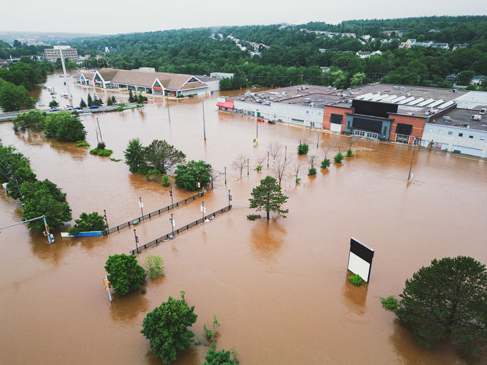
Post flood event inquiry, review, or analysis from around the world consistently points to the need for emergency managers to access up-to-date intelligence, the benefits of early warnings, the need for data sharing – both vertically and horizontally, and the criticality of timely situational awareness. At the heart of the recurring identification of this problem is the reality that whilst there are many detailed flood studies and flood risk maps available, there has been a deficiency of actionable real-time flood intelligence, and a lack to tools that emergency managers can use to generate this intelligence.
In Australia, these themes were repeated in the findings and recommendations of the Royal Commission into National Natural Disaster Arrangements which pointed to frustrations borne from the operational inadequacies of flood engineering and modelling techniques to meet the needs of the emergency managers.
Flood studies and flood risk maps provide critical information to engineers, planners and residents alike to inform infrastructure design, development planning and house purchases. But these resources (digital or pdf) are often static in nature. They are not designed to be operational, but to answer specific scenario based questions for the audiences mentioned. Emergency managers have a very different use case for flood data. They are not so much concerned with what the 1% AEP flood extent is, but what is the flood extent right now, and what will it be in 24 hours time?
At FloodMapp, our goal is to produce easily accessible, high-quality, and on-time flood intelligence for this purpose. FloodMapp specialises in real-time flood intelligence delivering live flood inundation services before, during and after the event to support preparation, response, and recovery.
FloodMapp has created a world-first software with core features that set it apart from all other flood modelling software and engineering solutions. Our real-time flood modelling technology DASH (Dynamic Automated Scalable Hydroinformatics) is capable of reading in live rainfall, river and coastal data to simulate flood inundation in real time with rapid updates every hour.
Our ForeCast, NowCast and PostCast deliver flood extent and depth intelligence before, during and after a flood to provide emergency managers with situational awareness and a common operating picture as a flood event unfolds. These solutions are built to deliver such intelligence directly to ArcGIS products.
These solutions are purpose built for emergency managers confronting flood risk. Their genesis is in solving the unmet flood intelligence needs of the disaster management community.
Our solutions are not being repurposed for emergency management – their only purpose is emergency management.
To help explain what our software does, and how it works, we’ve used 5 key themes:
1. Operational – Our advanced software uses large scale pre-processing, scalable cloud databases and a high degree of automation to operationalise hydrology and hydraulic flood inundation models. In this way our modelling solutions and data services are continuously monitoring flood conditions, ingesting real-time data, running real-time flood simulations, and exporting real-time results. The result is a live data feed service which is native to GIS environments such as Esri ArcGIS online to create a truly Common Operating Picture (COP) and unrivalled situational awareness as a flood unfolds, for example which roads are impacted by flooding. This is distinctly different from static flood studies or flood hazard scenarios typically delivered by engineering consultants.

2. Real time – as soon as data sources update (ie from rain or river height gauges) our models can be updated and delivered to your GIS platform. We know that real-time is an overused and appropriated term, but when we say real-time we mean that our services can refresh flood extent and depth maps in seconds to minutes of ingesting updated data inputs.
3. Dynamic – as we are accessing live rainfall and river height data, our models are a highly accurate model representation of: live predictions (ForeCast), live ‘actuals’ data (NowCast) and recent peak flood extent (PostCast) as a flood is happening. We do not rely on look ups, ‘precooked scenarios’, interpolation of probabilistic flood maps or flood map libraries. FloodMapp solutions use actual rain and river observation data as an event unfolds and is therefore not constrained by the limitations of known or ‘studied’ events. In this way our solutions are able to capture and simulate minor, moderate and major events, as well as events of record. For the recent flood event that occurred in Gympie, emergency managers noted the dynamic nature of ForeCast and NowCast as one of the most helpful features. Gympie suffered its worst flooding since 1893, with Mary River peaking at 22.96m - unlike anything that they had previously seen. FloodMapp was able to predict and model the flood of record and fill that gap dynamically, in real time.


4. Scalable – Our rapid modelling technology means that our solutions can provide high resolution models (up to 1m) which are highly scalable. Our web services enable simple zoom-in/zoom-out capability, from street level out to a state-wide or national area.
5. Accurate – Our solutions have been used and trusted by emergency managers. Our team is dedicated to quality and applies a rigorous calibration and validation approach to all hydrological and hydraulic models. This response provides evidence to demonstrate our achievement of high and consistent levels of accuracy.

This is not a claim. This is our purpose-built and proven reality. This is innovation in emergency management for the 21st century.


Для регулярного читання про цифрові новинки та практичні сервіси можна додати до закладок цей сайт, де постійно з’являються різні тематичні матеріали. Подача інформації залишається доступною навіть для тих, хто не є фахівцем.
Якщо хочеться знайти ресурс, де серйозні життєві питання сусідять із легким пізнавальним контентом, можна звернути увагу на lifehata. Сайт охоплює теми взаємин, свят, побуту, народних уявлень, сновидінь і повсякденного спілкування, тому кожен розділ має власний характер і може бути корисним у різних ситуаціях.
Якщо хочеться урізноманітнити список сайтів для читання, варто звернути увагу на infosaray.com.ua. Тут є матеріали, які можуть стати у пригоді в різних життєвих ситуаціях.
Мені сподобався sutovychok.com.ua завдяки різноманітності матеріалів і доступному стилю викладу. Це хороший варіант для періодичного читання та пошуку корисних підказок.
На Poradka можна знайти як практичні поради для дому, так і матеріали про особистий комфорт, технології та дозвілля. Різноманітність тем робить сайт зручним для читачів, які шукають доступну інформацію на щодень.