
FloodMapp improves environmental and safety outcomes for coal seam gas provider
- Apr 27, 2023
- 3 min read

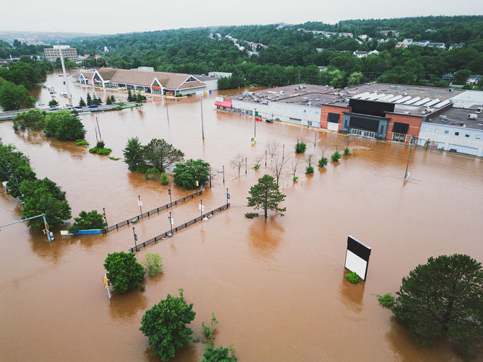
FloodMapp is working with a coal seam gas (CSG) provider in the Condamine River catchment to improve financial, environmental and safety outcomes of devastating flood events in Queensland and New South Wales. This powerful partnership highlights the significant difference innovative technology can bring to modern disaster management.
The CSG provider has successfully implemented the total FloodMapp product suite (ForeCast, NowCast and PostCast) for a selection of their CSG well pad assets located in the Condamine River catchment, which allows operators to understand the impact of a flood event before, during and after it hits.
FloodMapp’s groundbreaking flood model technology forecasts flood levels and delivers operational intelligence that enables the CSG provider to predict the potential impact of a flood before it happens, map the impact of current flood inundation in real-time, and quantify the impact zone after an event, within an hour of the floodwater receding. Understanding the localised impact of a flood on its assets and operations allows timely and actionable flood preparation, response and recovery activities.
Since partnering with the CSG provider in December 2021, FloodMapp’s world-first technology has been providing the supplier with hourly updates, 24/7, with 99.5% availability.
Let’s break down how they have implemented each tool.
ForeCast
FloodMapp ForeCast provides early warning of an impending flood up to 72 hours prior to an event, with the anticipated flood extent updated hourly, to assist flood preparedness activities. ForeCast has been delivered as a Web Feature Service (WFS) live mapping feed which seamlessly integrated with the provider’s in-house GIS system and enhanced their existing workflows.
ForeCast has been deployed to provide 24-hour and 72-hour forecast horizons to align with their Standard Operation Procedures (SOPs) and associated response plans. The 72-hour ForeCast data enables the CSG provider to complete risk level planning, powerful analytics, and make informed decisions based on the expected impact of a forecasted flood event. The 24-hour ForeCast data provides a greater level of certainty of the expected impact of a flood event and subsequently allows sufficient time for targeted operational activities to be carried out to prevent damage to assets and limit impact to operations.
FloodMapp ForeCast integrates with the client’s business continuity planning to ensure optimal operation of wells during a flood event. This includes actively managing the strategic closure of wells to prevent damage to assets and the environment, minimising impact on production and improving employee safety.
Prior to integrating FloodMapp’s products, the client was required to make decisions on the closure of wells during severe weather events which required employees to travel to and physically close wells during dangerous weather. However, due to the clear foresight intelligence FloodMapp data provides, the client is now able to assess the forecasted situation and close wells, if need be, ahead of time, preventing risk to employee safety.
This product has significantly improved financial and environmental outcomes while improving staff safety during flood operations.
NowCast
FloodMapp NowCast provides real-time situational awareness of the current flood extent for immediate response activities, with results updated every hour. This is critical information to understand whether assets are impacted without the need for site inspections.
Like ForeCast, NowCast was delivered as a WFS live mapping feed which seamlessly integrated with the provider’s in-house GIS system.
The client uses NowCast to assess and monitor the impacts to critical infrastructure as a flood event evolves. This prevents field staff needing to travel to site to assess the infrastructure during high-risk weather conditions. Any flood operation activities are instead prioritised and executed safely from the operations centre.
PostCast
FloodMapp PostCast, also integrated with the clients GIS system as a live mapping feed layer, provides the maximum flood extent and flood depth experienced in the past 30 days. Results are generated every 12 hours to enable maximum flood impact areas to be understood and recovery actions to occur sooner.
FloodMapp PostCast has been used to understand impact to operations, prioritise recovery activities to assets as flood waters receded and help improve future emergency operations planning.
About FloodMapp
FloodMapp was created and its products were developed with emergency managers and critical infrastructure agencies, like electricity and gas suppliers, in mind. CEO and Co-Founder Juliette Murphy said it’s great to see our technology put to such important use.
“Our products were specifically designed to help emergency managers improve safety and prevent damage, so it’s amazing to see this result for our client. We’re proud to assist them in achieving improved financial, environmental and safety outcomes,” Juliette said.
The value of FloodMapp flood intelligence is clearly shown through the integration with our CSG client in the Condamine River catchment.
To learn more, please request a demo or contact us via hello@floodmapp.com


What a fantastic piece! This really breaks down the topic in such an accessible and engaging way. 정보이용료현금화 Thanks so much for the thorough reporting!
Fantastic article! 정보이용료 현금화 This piece really captures the essence of the story and presents such compelling information. Thanks for keeping us all informed with quality journalism like this!
Fantastic piece! 정보이용료현금화 This is exactly the kind of thoughtful, well-researched journalism we need more of. Really appreciate you breaking down such a complex topic in such an accessible way!
Fantastic piece! This is exactly the kind of thoughtful, well-researched reporting we need more of. 정보이용료 현금화 Really appreciate you shedding light on this important topic!
The way you presented complex information so simply is remarkable. I appreciate the depth of research and clarity in your writing. bear clicker